Environment
The Beach That Came From a Channel
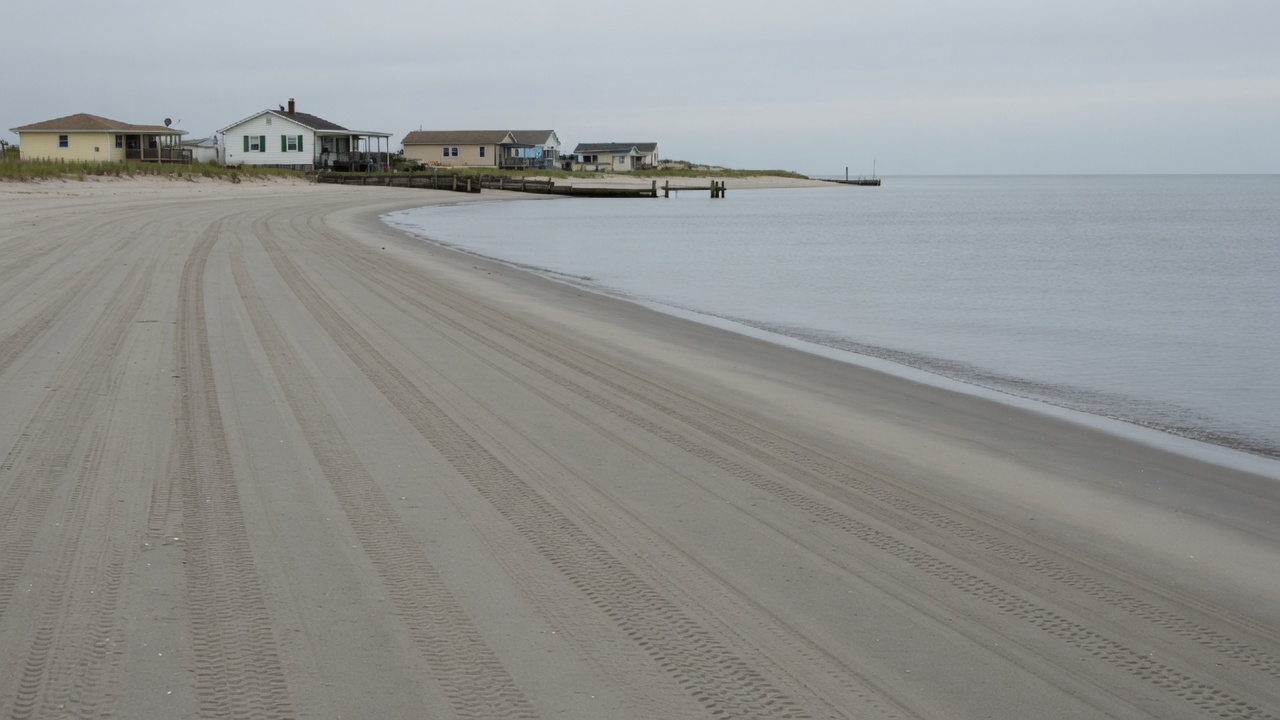
After Sandy, Ocean View got a wider shore. The sand had a job before it was a beach.
The new sand is easy to see. It is pale, even, wide enough for a towel and a storm. The places it left, and the lives it covered, are not.
After Superstorm Sandy in 2012, federal money that followed the disaster made it possible to build a beach that Norfolk and the U.S. Army Corps of Engineers had studied for decades. Along the Ocean View neighborhood—and the rest of the Willoughby Spit and vicinity shoreline, from near the Hampton Roads Bridge-Tunnel to Little Creek Inlet—the Corps dredged sand from the Thimble Shoal shipping channel, pumped it onto the Chesapeake Bay beach, and spread it with earthmoving equipment. The design was a protective berm on the order of sixty feet wide, sloping to about five feet above mean low water. The Corps records about 1.2 million cubic yards placed along roughly seven miles—7.3 miles in the project description—and the work completed in May 2017. Great Lakes Dredge and Dock ran the pumps. The construction cost was put at $34.5 million. Robert Pretlow, the Norfolk District project manager, told the city the job had finished on time and on budget, and that the shore was more resilient against wave energy in coastal storms.
Sandy did not, in other words, arrive with a pipeline. It arrived with a political weather that could fund a machine already on the books. A feasibility study had been completed in 1983. Authorization sat in the Water Resources Development Act of 1986. A limited reevaluation after Sandy, dated February 2014, turned paper into slurry. That distinction matters. A replenished beach is easy to file under “recovery.” Follow the sand, and the story is older, wetter, and less photogenic: a navigation channel, a food web, a fifty-year calendar, and a coast that is both sinking and being overtopped.
Two holes, one project
Thimble Shoal is not a spare pile of beach. It is a federal navigation channel at the mouth of the Chesapeake Bay, the path ships take toward the port of Norfolk. Auxiliary lanes beside the main channel were the preferred borrow site: a trailing suction hopper dredge lifting bottom sediment, a pipeline on the seabed, a slurry of sand and water arriving on a public shore.
That dual use is efficient in the language of civil works. A channel that must be maintained anyway can supply a beach that must be widened. The Corps’ project page is explicit about the marriage. Over a fifty-year life the shore is expected to receive about 445,100 cubic yards of fill every nine years, again from the Thimble Shoal auxiliary channel. Navigation gets a hole. The neighborhood gets a berm. The public ledger gets one dredge instead of two.
Efficiency is not the same as emptiness. The seafloor of a borrow site is habitat. Dredging removes the sediment and the animals that live in it—polychaete worms, clams, amphipods, the uncharismatic majority of a bay bottom. Motile fish can leave. The ones that live in the sand cannot. On the beach the same physics runs in reverse. A layer of fill thick enough to change a storm profile is thick enough to bury the resident invertebrates of the intertidal and shallow subtidal.
Coastal ecology has documented this pathway for decades, which is not the same as having documented this beach. Immediate mortality at the placement site is the physical expectation: animals that breathe through a few centimetres of sand do not breathe through a metre of new fill. What follows is a pulse of opportunistic species, then a recovery that depends on grain size, slope, season, the presence of nearby colonists, and whether the next load arrives before the community has finished returning.
Charles Peterson and Melanie Bishop, reviewing forty-six monitoring studies in BioScience in 2005, were already tired of being told that nourishment was biologically trivial. They found that only a small fraction of those studies controlled for both spatial and temporal variation; more than half, in their reading, reached conclusions the designs could not support. Monitoring was typically paid through project promoters. The literature was not empty. It was uneven, Atlantic-heavy, and often too short. That review is a warning label on every later number, including the ones that follow.
What the literature can say, and what Norfolk has not published
Some beaches rebound faster than others. Thomas Schlacher and colleagues, working on an Australian shore, found the upper and middle beach azoic two days after fill; five months later the lower shore had recovered in most respects while the upper beach near the dunes had not. Tyler Wooldridge, Heather Henter, and Joshua Kohn, following eight San Diego County beaches for fifteen months after a 2012 replenishment, saw nearly all taxa decline immediately. Talitrid amphipods and the bean clam Donax gouldii recovered within a year on those beaches—sooner than in several earlier studies. Polychaetes, which had been a large part of the community, remained depressed, so that overall invertebrate abundance on replenished sections was still about half that of controls at fifteen months.
Peterson, Bishop, and colleagues, following North Carolina fills that used unnaturally coarse, shelly sediment, found a longer injury. Haustoriid amphipods and Donax stayed suppressed for the entire three to four years of monitoring. Mole crabs recovered sooner. Ghost crabs lagged into the fourth summer. Foraging shorebirds were fewer for years. The coarse shell hash was not a brief pulse. It was a press disturbance: the beach remained a different beach.
Jeroen Wijsman, Theo Prins, Simeon Moons, and Peter Herman, reporting on a 2017 shoreface nourishment near Callantsoog on the Holland coast, found the macrobenthic community still unrestored four years later, with the sediment remaining coarser than before. Rakocinski and colleagues, on a Gulf beach loaded with fines, saw effects lasting more than two years. Jeroen Speybroeck’s European review, and later sandy-beach work by Jenifer Dugan and others, treat grain-size mismatch—too coarse or too fine, too much shell, too much silt—as the difference between a pulse an assemblage can absorb and a habitat conversion.
Ocean View is not those other beaches. We should not pretend a California or Florida or North Carolina transect is a Norfolk census. The Corps and the city have not, in the public documents that describe this project, offered a before-and-after invertebrate tally for the 2017 placement or for the Thimble Shoal auxiliary channel. That absence is not proof that the worms were fine. It is the ordinary condition Peterson and Bishop complained about: the width of the berm is measured; the animals under it are inferred from somewhere else.
What can be said without a local census is still not nothing. Established: burial kills infauna at the fill site, and dredging removes infauna at the borrow site. Probable: Ocean View’s intertidal community was reduced, then began to recover on a schedule measured in seasons to a few years, not in days. Plausible: if channel sand was a reasonable match to native grain, recovery was closer to the faster studies than to the coarse-shell studies. Unknown: how close, and whether the nine-year return will reset the clock before a fuller community returns. Habitat is an outcome. Compatibility is a design claim. Those are allowed to differ.
Grain size is not a detail
A beach is a sorting machine. Waves and the swash zone arrange particles by size and density. Animals that live in that machine are tuned to it: the depth they can bury, the water they can pump, the slope they can occupy. Fill that is too fine stays wet, goes anoxic, and can inhibit burrowing. Fill that is too coarse steepens the foreshore, reduces habitat area, and leaves a lag of shell that is hard on feet and harder on amphipods.
Corps environmental documents treat Thimble Shoal material as beach-compatible; they also describe mixed silts and sands in the channel. An auxiliary channel is not a borrowed dune. It is a shipping cut through bay bottom. Some loads will be cleaner sand than others. The first placement’s public description emphasises the sixty-foot width and the five-foot slope, not a grain-size curve. City monitoring after 2017, in periodic surveys by Moffatt & Nichol, tracks shoreline position and volume, not infauna. The median berm contour had already retreated tens of feet in places by 2021. That is the sand doing what sand does. It is also a reminder that the “match” is tested by the Bay, not by the press release.
There is a related, quieter variable: color, shell content, and the season of work. Winter fill can miss a recruitment window or hit one. Summer fill lands on a living beach. The 2017 pumps ran from roughly March into May—shoulder season, not a biological vacuum. None of that makes the project a crime. All of it belongs in the account.
The sand will not stay
A replenished beach is a temporary arrangement with the Bay. Waves and alongshore currents do what they did before the pipeline: they move particles. That is why the Corps’ project is not a single event. It is written as a fifty-year undertaking with periodic renourishment—on the order of every nine years, with city statements sometimes saying seven to nine as monitoring warrants—drawing again from Thimble Shoal. The Virginian-Pilot, reporting the partnership as it finished, described a public commitment to replace what washes away, at a cost that returns with the sand.
This is the hidden invoice. The first placement is visible: a wider Ocean View, more room between house and surf, a storm buffer that can be walked on. The second, third, and fourth placements are a habitat disturbance scheduled in advance. If recovery takes years and the dredge comes back on a nine-year clock, “temporary” becomes a cycle. Peterson’s coarse-sediment beaches had not fully recovered in four years. Manning’s San Diego beaches were still down at fifteen months. A nine-year interval may be long enough for much of the infauna to return, or it may be a rhythm of partial recovery and reset. That is a monitoring question. It is not answered by a width.
Fill that leaves the berm does not vanish. It feeds the nearshore bar, the shallows, the next spit. Some of the “lost” beach is still in the system, which is why coastal engineers speak of a sand budget rather than of disappearance. The animals of the shallow subtidal live in that budget. Melanie Bishop, Peterson, and colleagues, sampling an ebb-tidal delta after a large disposal of dredged sand meant to nourish down-drift beaches, found coarsened sediments and altered benthic assemblages not only where the material was dumped but at least a kilometre away. The nearshore is part of the project whether it appears in the ribbon-cutting or not. Ocean View’s nearshore is a different sea, a bay with a fetch to the north and swell leaking in from the east. The principle travels: the photograph of the dry berm is not the whole placement.
What the breakwaters already taught
Ocean View did not wait for Sandy to try to hold a shoreline. With the Commonwealth’s help in the late 1990s, Norfolk built a series of nearshore rock breakwaters along Willoughby Spit and Ocean View. State funding ended before the sand that was supposed to sit behind them was fully placed. Hurricane Isabel in 2003 then took much of the remaining berm and dune. The breakwaters remained: free-standing rubble mounds meant to knock down wave energy and trap sand moving alongshore.
Structures like that can widen a local beach by intercepting drift—and can starve a neighbor of the same sand. They are a reminder that every “solution” on a moving coast is also a transfer. City survey reports still name the fields: the 800 Block breakwaters, Central Ocean View, Bay Oaks, East Beach. After the 2017 federal fill, some of those pockets held sand better than the open reaches. Some ends of fields eroded faster. In 2020 the city modified a breakwater near 11th View Street and added another; sand began to collect in the lee within a year. That is the trap working as designed.
The Corps project and the breakwaters are not rivals so much as stacked interventions. The rocks hold a fraction of what the pipeline delivers. Downstream, or at the gaps, the budget is still open. Virginia Places, a public geography project, notes a further bureaucratic irony: the existing breakwaters had at one time complicated Ocean View’s eligibility for federal nourishment. After Sandy the rules and the money aligned. The sand came. The rocks stayed.
Nourishment transfers in a different direction from a breakwater: from a channel floor to a recreational and protective berm, then slowly back into the Bay. The boardwalk sees the berm. The Bay receives the rest. A tombolo behind a breakwater is a public beach that was assembled from other people’s drift. Honesty is not hostility to either structure. It is the habit of asking who paid in sand.
A coast that is sinking as the water rises
Storm damage is not imaginary. Houses, roads, and a working waterfront sit on one of the fastest relative-sea-level coasts on the Atlantic seaboard. The NOAA tide gauge at Sewells Point, a few miles from Ocean View, has a record beginning in 1927. The linear relative trend NOAA now publishes for that station is about 4.84 millimetres per year, roughly 1.59 feet per century, with a narrow confidence interval on a nearly complete hundred-year series. Older published rates for 1927–2006 were about 4.4 millimetres per year. The number moves as the series lengthens. The direction does not.
Relative sea level is the sum of water rising and land falling. Jack Eggleston and Jason Pope, in USGS Circular 1392, put southern Chesapeake land subsidence in the range of about 1.1 to 4.8 millimetres per year over the last three-quarters of a century, enough to account for more than half of the relative rise measured in the region. Groundwater pumping compacting the Potomac aquifer system explains a large share of that subsidence; glacial isostatic adjustment—the lingering flex of the crust after the ice sheets—explains another. Recent GPS work has suggested that some of the pumping-related sinking has slowed as withdrawals changed, while the tectonic and isostatic components remain. Hampton Roads Planning District guidance still tells localities to plan for on the order of 1.5 feet of relative rise by mid-century in near-term design, with higher figures for longer-lived projects.
A sixty-foot berm is a real buffer against the waves of a nor’easter. It is not a rebuttal to a tide gauge. Each renourishment is, among other things, an adaptation to a moving baseline: the still-water line creeps, the storm hydrograph sits higher, the same profile intercepts a different ocean. The fifty-year project life assumed a repeating fill. It did not assume a finished climate. Whether 445,100 cubic yards every nine years will be enough in year forty is a question the sand budget will answer whether or not the original report did.
Willoughby Spit itself is a storm artifact, formed, in the local historical account the Corps repeats, around a hurricane in 1749. The spit has always been a conversation between wave approach, inlet, and supply. Ocean View’s houses are a later sentence in that conversation. Nourishment is how a city keeps the sentence from ending. It is also how a city commits its grandchildren to a dredge.
Living shorelines where they fit
Not every Norfolk edge is a recreational bay beach with a federal project. Creeks, tidal creeks, and fetch-limited shores around Hampton Roads face the same relative rise with a different toolkit. Virginia, after a 2010 VIMS study and Senate Bill 964 in 2011, named living shorelines the preferred alternative for tidal shoreline stabilization. Senate Bill 776 in 2020 went further: the Marine Resources Commission is to permit only living-shoreline approaches unless the best available science shows the site is not suitable, and even then to require living-shoreline elements to the maximum extent possible. VIMS’s Center for Coastal Resources Management writes the technical guidance: marsh fringe, sand fill, stone sills, the strategic use of plants and rock to keep a bank and a habitat at the same time.
A living shoreline is not a substitute for a seven-mile storm berm on a high-energy bayfront. Donna Bilkovic and others at VIMS have been frank that property owners still doubt whether marsh and sill match bulkhead performance in a blow, and that Hampton Roads already has some of the most heavily armored shoreline in the state. The 2020 mandate met resistance. Permit data still show plenty of riprap. The point is not to pretend a Spartina fringe would have held Ocean View in Isabel. The point is that the region’s problem is not one geometry. Where fetch is short and the bank is a marsh, hardening trades habitat for a wall that then needs a higher wall. Where the shore is already a public beach with a navigation channel full of compatible sand, nourishment is the tool the Corps knows how to fund.
Dual use remains the interesting civic fact. Deepening Thimble Shoal for larger ships produces a spoil that can be a resource or a disposal problem. Beneficial use of dredged material—placing channel sand on a beach instead of in a deep hole—is older than Sandy and will outlive this project. The ethical content of that reuse depends on grain size, season, and whether anyone counts what lived in both holes. A harbour and a neighborhood bound together by slurry is not a metaphor. It is a pipe.
A good intention, still a hard question
A wider beach can reduce wave energy that would otherwise spend itself on piles and pavement. That is the Corps’ stated purpose, and it is a legitimate one. Residents who gained a dry berm in 2017 gained a real thing: recreation, a storm buffer, a property line that did not move inland that year. Flying River does not require us to hate the assignment.
The question the ribbon-cutting does not ask is the one this publication exists to ask. What is happening here that most people can’t easily see? A seafloor community converted into a public beach. A food web for fish and shorebirds interrupted on a construction schedule, on evidence from other coasts because this coast was not fully inventoried. A navigation channel and a neighborhood sharing a borrow pit. A relative sea level of nearly five millimetres a year, half or more of it the land going down. A promise, renewed every nine years, that the interruption can be done again. Breakwaters that hold sand in one pocket by denying it to another. Living shorelines that fit the creeks and do not fit this fetch, and that still belong in the same regional sentence.
What happens if we follow the connection far enough? We stop calling the result “the beach,” as if it had always been there, and start calling it what it is: sand on assignment, with a borrow site, a burial, a grain-size bet, a sinking city, and a return date.
You don’t have to oppose a wider beach to ask where the sand was yesterday. When a replenishment is announced, look for the borrow site, the grain-size match, the season of work, and whether anyone will count invertebrates afterward—not only the new high-water line. Treat the nine-year return as part of the project, not as a surprise. Support living-shoreline and floodplain approaches where they fit, and monitoring where nourishment is still the tool on the table.
That does not require us to refuse the assignment. It requires us to count the places that never make the photograph.
Sources
- U.S. Army Corps of Engineers, Norfolk District. “Willoughby Spit & Vicinity Coastal Storm Damage Reduction Project.” Project page, including scope (7.3 miles; 1.2 million cubic yards; 60-foot beach; slope to 5 feet above mean low water), completion in May 2017, 50-year life, and 445,100 cubic yards every nine years from the Thimble Shoal Auxiliary Channel.
- U.S. Army Corps of Engineers, Norfolk District, and City of Norfolk. “Willoughby and Vicinity Project Coming to a Close.” 19 May 2017.
- “Norfolk Beach Replenishment Project at Ocean View Completed.” The Virginian-Pilot, 22 May 2017.
- Dredging Today / USACE progress notes, April–May 2017 (Great Lakes Dredge and Dock; placement totals toward 1.2 million cubic yards).
- Water Resources Development Act of 1986, § 501; Norfolk District feasibility study (1983) and post-Sandy limited reevaluation report (19 February 2014).
- Peterson, Charles H., and Melanie J. Bishop. “Assessing the Environmental Impacts of Beach Nourishment.” BioScience 55, no. 10 (2005): 887–896.
- Peterson, Charles H., Melanie J. Bishop, Linda M. D’Anna, and Galen A. Johnson. “Multi-year Persistence of Beach Habitat Degradation from Nourishment Using Coarse Shelly Sediments.” Science of the Total Environment 487 (2014): 87–96.
- Peterson, Charles H., Melanie J. Bishop, Galen A. Johnson, Linda M. D’Anna, and Lisa M. Manning. “Exploiting Beach Filling as an Unaffordable Experiment: Benthic Intertidal Impacts Propagating Upwards to Shorebirds.” Journal of Experimental Marine Biology and Ecology 338, no. 2 (2006): 205–221.
- Schlacher, Thomas A., et al. “The Effects of Beach Nourishment on Benthic Invertebrates in Eastern Australia: Impacts and Variable Recovery.” Science of the Total Environment 435–436 (2012): 411–417.
- Wooldridge, Tyler, Heather J. Henter, and Joshua R. Kohn. “Effects of Beach Replenishment on Intertidal Invertebrates: A 15-Month, Eight Beach Study.” Estuarine, Coastal and Shelf Science 175 (2016): 24–33.
- Bishop, Melanie J., Charles H. Peterson, Henry C. Summerson, Hunter S. Lenihan, and Jonathan H. Grabowski. “Deposition and Long-Shore Transport of Dredge Spoils to Nourish Beaches: Impacts on Benthic Infauna of an Ebb-Tidal Delta.” Journal of Coastal Research 22, no. 3 (2006): 530–546.
- Rakocinski, C. F., R. W. Heard, S. E. LeCroy, J. A. McLelland, and T. Simons. “Responses by Macrobenthic Assemblages to Extensive Beach Restoration at Perdido Key, Florida, U.S.A.” Journal of Coastal Research 12 (1996): 326–353.
- Wijsman, Jeroen W. M., Theo C. Prins, J. J. Simeon Moons, and Peter M. J. Herman. “Changed Sediment Composition Prevents Recovery of Macrobenthic Community Four Years after a Shoreface Nourishment at the Holland Coast.” Estuarine, Coastal and Shelf Science 293 (2023): 108521.
- Speybroeck, Jeroen, et al. “Beach Nourishment: An Ecologically Sound Coastal Defence Alternative? A Review.” Aquatic Conservation 16 (2006): 419–435.
- Dugan, Jenifer E., David M. Hubbard, Ivan F. Rodil, David L. Revell, and Stephen Schroeter. “Ecological Effects of Coastal Armoring on Sandy Beaches.” Marine Ecology 29, no. s1 (2008): 160–170.
- Eggleston, Jack, and Jason Pope. Land Subsidence and Relative Sea-Level Rise in the Southern Chesapeake Bay Region. USGS Circular 1392, 2013.
- NOAA Center for Operational Oceanographic Products and Services. Relative sea-level trend, Sewells Point, VA, station 8638610 (record from 1927; published linear trend on the order of 4.8 mm/yr).
- Hampton Roads Planning District Commission. Regional sea-level rise planning guidance and Regional Resilient Design Guidelines (Sewells Point as reference gauge; near-, mid-, and long-term relative-rise figures).
- City of Norfolk. Ocean View sand management and periodic survey evaluations (Moffatt & Nichol), including post-2017 shoreline change and breakwater-field performance.
- Hardaway, C. Scott, Jr., and colleagues, Virginia Institute of Marine Science. Living Shoreline Design Guidelines for Shore Protection in Virginia’s Estuarine Environments; and CCRM guidance on breakwaters and tombolos.
- Code of Virginia § 28.2-104.1 (living shorelines as preferred, then default, alternative; SB 964, 2011; SB 776, 2020).
- Virginia Places. “Beach Replenishment,” account of Ocean View breakwaters, federal eligibility, and the 2017 placement.
The new sand is easy to see. The places it left, and the lives it covered, are not.
Follow the connection
- Storm damage
- Channel dredging
- Borrow site
- Pipeline
- Beach fill
- Drift and burial
- Next cycle
What we know
- After Hurricane Sandy in 2012, federal disaster funding helped construct a long-planned storm-damage reduction project along Norfolk’s Ocean View and Willoughby Spit shoreline.
- The U.S. Army Corps of Engineers used sand dredged from the Thimble Shoal auxiliary shipping channel, pumped onto the bay beach and graded—about 1.2 million cubic yards along roughly seven miles, with a design berm on the order of 60 feet wide. The Corps records the work as completed in 2017.
- The project is designed as a repeating commitment: periodic renourishment, on the order of every nine years, over a 50-year life, again drawing on channel sand.
- Beach nourishment and borrow-site dredging remove or bury seafloor and beach invertebrates. That physical pathway is well established in coastal ecology.
- Fill does not stay put. Waves and currents move it alongshore and offshore, which is why the schedule includes more sand later.
What remains uncertain
- How long benthic communities took to recover at Thimble Shoal and on the Ocean View beach after this specific placement is not something a width measurement answers.
- How closely channel sand matches native grain size—and therefore slope, holding time, and habitat—varies by reach and by load.
- Whether repeated nine-year cycles prevent a fuller recovery, or merely reset it, is an open monitoring question.
- Storm-damage reduction can be real without being free. The net account (houses, habitat, navigation, public cost) is a policy judgment, not a single scientific number.
What can we do?
You don't have to care about this because everyone else does. You can care because the evidence gives you a reason to.
- You don’t have to oppose a wider beach to ask where the sand was yesterday.
- When a replenishment is announced, look for the borrow site, the grain-size match, the season of work, and whether anyone will count invertebrates afterward—not only the new high-water line.
- Treat the nine-year return as part of the project, not as a surprise.
- Support living-shoreline and floodplain approaches where they fit, and monitoring where nourishment is still the tool on the table.
Demonstration authors are fictional. The phenomena discussed are real subjects of public scientific literature and reporting. Sources named in the article are documented; this is not a comprehensive literature review.